The Road to Machu Picchu Part 4: Cusco to Ollantaytambo

The Road to Machu Picchu Part 4: Cusco to Ollantaytambo

Samuel Roger Holmes No Comments

There is a beautiful feeling of serenity at the spectacular former Incan city of Machu Picchu. The long road through the Andes to this remote paradise is not so well acclaimed, but is also very special. This is a journey unlike any you will ever have undertaken before, and it will stay with you forever. Getting to the jewel of the Sacred Valley can be costly and time consuming, but it is a journey which is to be enjoyed rather than endured. This is my 6-part travelogue, revealing the highlights of the road to Machu Picchu, including Chinchero.

Machu Picchu

Machu Picchu – One of the most beautiful places in the world

Cusco to Ollantaytambo

The anticipation and excitement ahead of the onward journey to Machu Picchu is probably the only thing that softens the disappointment you feel when it is time to leave Cusco. The capital of the Andes has a strong magnetic lure, and leaves you wanting more. But it was time to leave, and head further north. Further into the Andes. And closer still to Machu Picchu.

The journey from Cusco to the wonderfully named Sacred Valley town of Ollantaytambo takes approximately 90 minutes. Although the city stands at over 11,500ft, and Machu Picchu is at a lower altitude, the road ascends further on the first section of the trip. This is because Ollantaytambo, and The Sacred Valley are on the other side of a vast upland plateau which must be traversed. From the centre of Cusco, the road corkscrews up through some of the city’s poorest neighborhoods, notably Los Huertos and Chanachayoc, where stereotypical South American shanty huts cling to the steep hillside.


20150813_111052-1

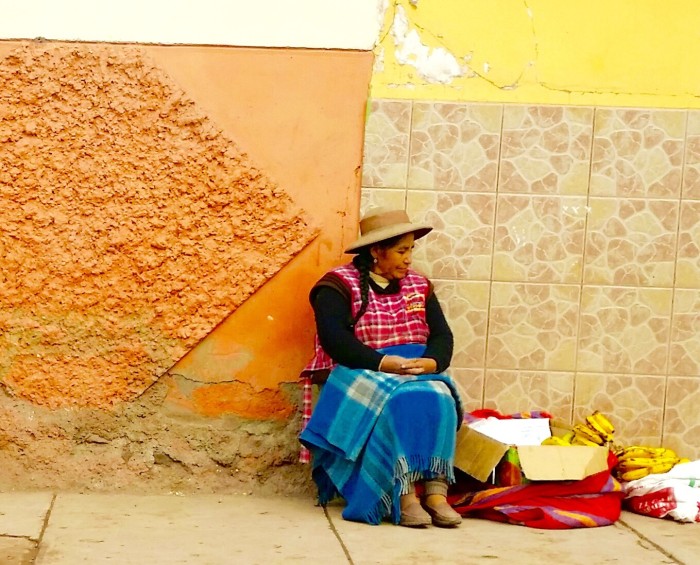
Young woman in poorer district of northern Cusco, Peru


20150813_103132-1

Selling bananas on the street at Los Huertos, Cusco, Peru


2015-08-13 20.39.43

Woman in Chanachayoc District of Cusco, Peru

After tipping over the top of the mountain, the road then descends for several miles, before eventually flattening out as it crosses the magnificent Anta Plateau. This is home to some of Peru’s finest agricultural lands.

The town of Chinchero, at an altitude of 14,500 feet, is of particular interest, for it is here that a window into South America’s ancient past can be seen. The town’s 15,000 strong population, their language and culture, are almost entirely of Quechuan descent, which predates the Spanish conquistadors, and even the Incan empire. The townspeople can still be seen wearing traditional attire, and the area is noted for it’s self sufficiency and handmade arts and craft markets. There are also many Incan sites in the locality which are of great cultural significance.


20150813_104319-1

The road through Chinchero district, near Cusco, Peru


20150813_110759-1-1-1

Two ladies in traditional attire, waiting for a bus at Chinchero, near the city of Cusco in Peru.

Having lost a day on the trip due to being stuck in snow at high altitude en route from Arequipa, my tour guide had arranged for a taxi to take us on this journey as opposed to the tour bus as originally planned. As with many of the aspects of the trip, the contingency plan actually turned out to be a blessing in disguise, because we now had not only a driver, but a personal guide. The taxi driver, an amicable man called Aurturo, had great pride in his home region and was happy to discuss the points of interest along the route.

After telling me about all of the traditional culture in Chinchero, Aurturo then told me that the adjacent plateau is the site of a planned new international airport which will completely open up the area to yet more tourists. By 2025 people living near a major airport will be able to fly to within an hour of Machu Picchu and The Sacred Valley. We had a constructive debate about the merits of this development.

2015-08-13 20.32.23

The agricultural plateau near Chinchero, soon to be home to Cusco International Airport

There is no doubt that the huge new international airport will bring more tourists to Machu Picchu, and create business opportunities for locals. But it will also dilute the ancient and unique ambience of Chinchero, filter people away from Cusco, put Machu Picchu itself under logistical strain and deprive visitors such as myself of seeing the beautiful panoramas on the more remote roads through the Andes.

Sill, progress is progress. Aurturo welcomed the news, but later admitted that this opinion was from a business perspective. He revealed that he may have plans to operate a private bus company to engage with the expected international tour operators. The airport project is being funded mostly by German and Brazilian venture capitalists. In truth, while progress is to be welcomed, I felt sad that Chinchero, one of the last fully authentic towns in the area, may soon be transformed in the name of globalization and mass tourism.

2015-08-13 20.33.39

Arriving in The Sacred Valley, in the Andes Mountain range Peru en route to Machu Picchu

Having crossed the massive plateau, we finally came within sight of the Sacred Valley, and began the hair-raising descent through a series of corkscrews into Urubamba, the town which shares it’s name with the river which flows through the valley in the direction of Machu Picchu. The last leg of the trip, was to follow the river northwards for several miles to the small but bustling town of Ollantaytambo, where along with many other backpackers and tourists, we would take the iconic train journey to Aquas Calientes. By now, the excitement of approaching Machu Picchu was making it almost impossible to fully enjoy the surroundings along the route.


Have you read the other posts in this series?

Part 1: Arequipa

Part 2: Arequipa to Cusco

Part 3: Cusco

Part 5: Ollantaytambo to Aquas Calientes

Part 6: Aguas Calientes (Machu Picchu Pueblo)

The Road to Machu Picchu Part 3: Cusco

Samuel Roger Holmes No Comments

There is a beautiful feeling of serenity at the spectacular former Incan city of Machu Picchu. The long road through the Andes to this remote paradise is not so well acclaimed, but is also very special. This is a journey unlike any you will ever have undertaken before, and it will stay with you forever. Getting to the jewel of the Sacred Valley can be costly and time consuming, but it is a journey which is to be enjoyed rather than endured. This is my 6-part travelogue, revealing the highlights of the road to Machu Picchu, including Cusco.

Machu Picchu

Machu Picchu – One of the most beautiful places in the world

Cusco

Often referred to as the cultural and architectural capital of South America, Cusco was the capital of the former Inca empire, and in more recent times has been declared a UNESCO World Heritage site, attracting over 2 million visitors per year.

Sitting at almost 11,500 feet, this cosmopolitan capital of the Andes serves as the epicenter of Inca tourism. Any trip to Machu Picchu, The Sacred Valley and The Inca Trail, will include at least a passing visit to Cusco.

Having lost a day owing to being stuck in snow en route at 14,000 feet, I had only a few hours to catch a glimpse of Cusco. I arrived after sun down, and immediately took a stroll around the obvious first port of call: the Plaza de Armas. I was greeted by a statue in honor of Pachacuti, the Inca emperor for whom apparently, Machu Picchu was constructed as an Andean sanctuary.

Pachacuti

Statue of Inca Emperor Pachacuti

I did not get much further before having to buy a chullo (traditional Peruvian hat with tassels, which made from the wool of the alpaca). I had come from the warmer climes of Arequipa in the south, and although I had gone through a snowstorm en route, the cooler temperature and rain in Cusco were something of a shock. The weather at this altitude can be unpredictable, so I would advise anyone visiting the area to prepare for four seasons.

My nocturnal ramble through the cobbled streets of old town Cusco was cut short by even heavier rain, and I made my way back to the Hotel del Inca, stopping along the way with a street vendor to buy some hot herbal tea. This brew of cocoa leafs fused with various local herbs is used for acclimatization to the altitude, and as a general health supplement. It certainly warmed me up, and possibly helped in preventing altitude sickness, but I remain skeptical about recommending it. Although the beverage is popular in South America, I have since learned that it is not legal outside of the continent owing to the raw cocoa element. Who knew.

Back at the hotel I climbed under what seemed like far too many woolen blankets, and fell into one of the best sleeps I’ve had in years. I don’t often remember dreams, but that night I dreamt that I was hiking through the Andes, discovering ancient ruins unseen by modern man. Maybe the herbal brew had some impact after all.

I awoke the following morning feeling very well rested. Pulling back the curtains, I discovered the nice surprise of seeing a beautiful view out over the neighboring rooftops to the Andes Mountains in the background. Something about that panorama made me stop and appreciate the marvelous journey that I was undertaking. I stayed with that moment, and also practiced The Paris Method, and it really set me up for a great day.

Cusco rooftops

Panoramic view from the hotel room in Cusco, Peru

After breakfast I went back to the Plaza de Armas, and visited the Cathedral Basilica of the Assumption of the Virgin. After almost 100 years under construction, this gothic-renaissance church was finally completed in 1654, and today not only serves as a place of worship, but as a museum for local Incan artifacts and as an art gallery. It is very well worth a visit. Just be careful not to use your camera inside, as there is a strictly enforced no-photography policy for some reason.

20150812_231731

The old Cathedral at Plaza de Armas, Cusco, Peru

Just across the Plaza de Armas is the National University of Saint Anthony the Abbot. The notion of the university was proposed by Pope Innocent XII, supported by Spain’s King Charles II. It was eventually established in 1692 just decades after the Conquistadors had beaten the Inca’s following the Siege of Cusco. These days the university has 29 academic departments, 37 professor chairs, and amongst other disciplines, has been to the fore of research and documentation of the ancient cultures of the area, and the Andes in general.

Plaza de Armas, Cusco, Peru

Cobbled streets around the Plaza de Armas, Cusco, Peru


20150813_094333

The courtyard in the National University, Cusco, Peru

My time in Cusco was unfortunately too short, but it has left me with a strong desire to return and explore the city further. It would be no stretch of the imagination to suggest that you could spend a week based in Cusco and still not see everything the city and surroundings have to offer. For now though, it was time to leave, and edge closer to Machu Picchu.


Have you read the other posts in this series?

Part 1: Arequipa

Part 2: Arequipa to Cusco

Part 4: Cusco to Ollantaytambo

Part 5: Ollantaytambo to Aquas Calientes

Part 6: Aguas Calientes (Machu Picchu Pueblo)

What’s in a name?

Samuel Roger Holmes No Comments

I have spent the past few days wondering if the name of this blog is appropriate, but have now decided to proceed as planned.

For some time now, I have been quietly preparing content for my book and blog, both entitled The Paris Method™. I have not as yet made either public, choosing instead to generate ample content prior to unveiling my work.

Late in the evening of Friday November 13th, I had been watching the international soccer match between Bosnia Herzegovina and the Republic of Ireland. Just after the final whistle, news began to filter through of the emerging terror attacks in the French capital Paris.

Like most people, I followed television news networks and social media as the full extent of the horrifying and unprecedented attacks emerged. In the early hours of Saturday morning I went to bed in sombre mood.

Upon awakening late the following morning, it occurred to me that the naming convention for my blog may now be inappropriate. Paris, for so long synonymous with love and romance, culture and civilization, may now also have a very different connotation.

However, having taken a few days to consider this, I have decided to proceed with The Paris Method™ name. Life changes and evolves, sometimes shocking and disgusting us. There are times when we will want to turn our faces away from life’s uglier events. But, in the spirit of staying true to ourselves and to our convictions, we should not change our own being due to the evil actions of others.

We may have to live on life’s terms, and that life can sometimes be frighteningly cruel, but if anything, that should only make us all the more convinced that we believe in ourselves and in the overall good in the world. The Paris Method™ will remain as the name for my book and this blog. I have decided this for myself, and to show solidarity with my many French friends. C’est la Vie, et C’est The Paris Method™.

Wild Atlantic Way – The Signs are Good for Donegal

Samuel Roger Holmes No Comments

Donegal has for a long time been the poor relation among the counties of Ireland’s western sea-board in terms of tourism revenue. Be it as a consequence of peripheral remoteness, lack of infrastructure, geographic proximity to the formerly troubled Northern Ireland, or simply due to a lack of marketing, Donegal has been lagging behind its southern counterparts. However, the ‘forgotten county’ may soon be seen and appreciated by millions of people around the world, if the new Wild Atlantic Way signs have their intended impact.

Fáilte Ireland, is to be highly commended for its vision and marketing prowess when conceiving the Wild Atlantic Way brand. Linking Ireland’s most northerly point at Malin Head to the Old Head of Kinsale in the south, via the entire Atlantic coastline, has been a master stroke. The points of interest, hidden gems and seaside towns along the route have since seen a year on year increase of 10%  in overseas visitors.

While Westport, Galway, the Cliffs of Moher, the Burren and Killarney have traditionally been magnetic tourist hubs, the Wild Atlantic Way aims to get the more adventurous holiday-maker out along the entire west coast of Ireland.

The first wave (pardon the pun) of rollouts from the Wild Atlantic Way project were the updated road signs which help to guide visitors along the meandering highways and byways. The next project milestone was the marketing blast. Fáilte Ireland was very specific regarding their target audience, with huge campaigns launched in North America and Europe, where there is already a palate for Irish vacations. There have also been escorted promotional tours for Asian journalists and bloggers, who have since brought the Wild Atlantic Way into the hearts of millions of potential visitors from newer markets.

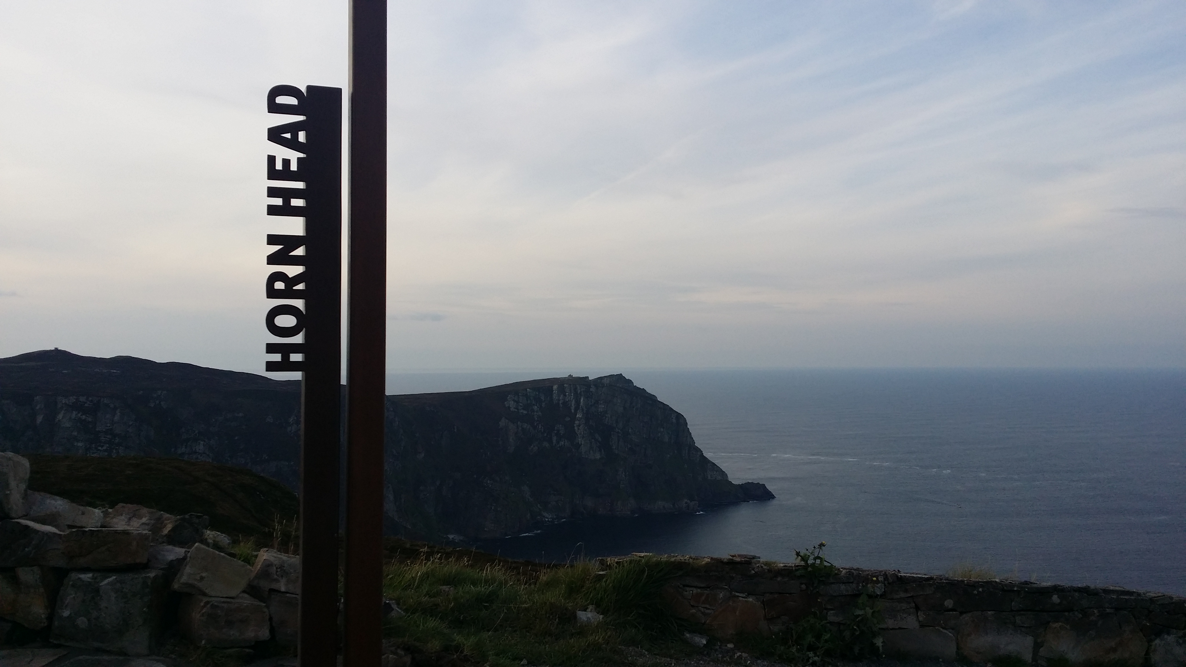
By mid-summer 2015 the landmarks themselves received their first aesthetic upgrade, with the erection of unique identification signs. There has been some criticism regarding their visual protrusion. Any protrusion however, is owing more to marketing strategy than design flaw.

The boxed metal signs which incorporate the Wild Atlantic Way logo and the name of each landmark, really do scream out to the visitor: ‘Hey! Photograph me! Show your friends where you have been, and collect photos of the many other signs too!’

This is really clever marketing by Fáilte Ireland. They are using the actual product to market itself. It encourages visitors to capture the names of the places in their photographs, giving the places a very definite identity, a link to a successful brand, and they encourage the visitor to collect photographs at the other locations too. There is no need to ‘check in’ photographs, as this is not so much about digital tagging. It is physical tagging. These tourist photos will be seen by millions, and the name of the place is right there in the shot. Also, for the tourist, the lure of the signs is a bit like football stickers; if a kid gets a few then he wants them all. From this point onwards, you won’t just visit Westport or the Cliffs of Moher, you will visit a single point on the Wild Atlantic Way.

This connection between the unique places and an overall brand is of particular benefit to Donegal. The Cliffs of Moher currently attracts over a million visitors per annum. The other tourist hubs of the west bring that number higher still. If only a fraction of those tourists become aware of Donegal’s undoubted natural beauty and many attractions as a result of the identification signs, then suddenly there is a captive audience. For marketeers, having a captive audience as the result of state sponsored advertising is like shooting fish in a barrel. If 1 million people like to visit the Cliffs of Moher in a year, then selling other cliffs under the same brand should not be problematic.

The spectacular sea cliffs at Sliabh Liag, which are among the highest in Europe, are an obvious attraction. Banba’s Crown at Malin Head has natural beauty combined with the distinction of being Ireland’s most northerly point. Fanad Lighthouse now offers tourist accommodation and the prospect of climbing to the top of the lighthouse itself, where the panoramic views are among the finest on the Wild Atlantic Way.


Fanad_Lighthouse

Fanad Lighthouse, in north Donegal

Lighthouse at St John's Point

Lighthouse at St John’s Point

St John’s Point, which remarkably juts 7 miles out into Donegal Bay, Rathlin O’Birne Island just beyond Sliabh Liag, Inishtrahull Island off Malin Head and the quaint seaside at Stroove all have picturesque lighthouses which are well worth exploring.

Donegal is famed for the many outstanding beaches on its staggering 772-mile coastline. Blue Flag beaches are to be found at the ‘back strand’ in Falcarragh, the shorefronts of Buncranna and Bundoran, at Coral Beach on St Johns Point, at Dooey near Lettermacaward, in Downings, Fintra Beach near Killybegs, Five-Finger Strand (which is home to the largest sand dunes in Europe), the beach near singer Daniel O’Donnell’s home in Kincasslagh, at Kinnagoe Bay where some of the Spanish armada washed ashore, Magheroarty Beach where you can catch the ferry to Tory Island, Murvagh, Pollan Bay near Ballylifin, the surfers’ paradise at Rossnowlagh and at Tra na Rosann.

Ballymastocker Bay near Portsalon, was voted the 2nd most beautiful beach in…wait for it…THE WORLD! Yes you read that right. Ballymastocker was bettered only by a beach in the Seychelles. To put the other beaches of Donegal in perspective, many local folk would not even consider Ballymastocker the most beautiful beach in Donegal! That gives a good indication as to the calibre of beach in the county.

With at least 25 further top quality beaches, among them Bunbeg – home to the iconic Bád Eddie which appeared in a music video by U2’s Bono and Clannad  (1.5 million views on youTube). Donegal has arguably the finest stretch of coastline in all of Europe for diverse, naturally beautiful and unspoiled beaches.

The real beauty is that on any given day, you will have them all to yourself. Indeed, Donegal man William Holmes is so impressed by the splendid remoteness of Tramore, to the west of Dunfanaghy, that he has renamed it ‘Solitude’. Access to this heavenly beach requires a peaceful 1.5 mile trek through forrest and over some of the most expansive sand dunes in Ireland.

Donegal also sits at the top table in terms of golf courses. Murvagh, Naran and Portnoo, Rosapenna, Portsalon and Ballylifen are undoubtedly world-class links courses, and the region also includes some fine parkland courses; notably Barnhill in Letterkenny.

If this wasn’t enough, you can venture further off the beaten track to find some of the most amazing coastal locations that you will ever visit, such as Port and Glenlough, with its barren and breathtaking cliffs, stacks, caves and sea arches. Should the coastline leave you overawed, you can venture inland to the wonderful Glenveagh National Park, climb Mount Errigal, or take a shopping day in Letterkenny which was voted Ireland’s Tidiest Town in 2015. The lovely village of Fintown, where the Foyle and Finn sources are found, snuggles into the northwest face of the Bluestack Mountains, and offers a chilled-out train ride along the serene Lough Finn.

Further up in the Bluestacks, Lough Belshade, one of the most untouched places in all of Ireland, offers the more adventurous campers the chance to really get out into the wild. The Poisoned Glen in Dunlewey is another geological marvel. Best seen from the summit of Errigal, Poison Glen, or Heavenly Glen (take your pick depending on a one letter variation in the Gaelige name ‘An Gleann Neamhe’) is steeped in fairytale and folklore, and even has its own resident ghost – The Green Lady. Geologically, this glen, is a fine example of a glacial corrie (or cirque). In fact, most of Donegal is of geological interest, with many of the area’s mountains and valleys cut from the same retreating glaciers that shaped the Scottish Highlands. There are several examples of raised beach systems which act as a museum on Ireland’s tectonic timeline.

Perhaps history is your special interest. If so, then the 6th century home of the Gaelic Kings at Grianan of Aileach will fascinate you, as will Rathmullan – scene of the flight of the earls in 1607. Kilclooney Megalithic Tomb, near the bustling town of Ardara, is one of the finest such examples in Ireland. Beltany Stone Circle in Raphoe is believed to be two and a half thousand years old. The county is also richly populated by castles and forts, for example Doon Fort, which is built upon a clearly defined crannóg on Lough Doon,and is 4000 years old.

So why, you may ask, is this wonderfully beautiful, unique and welcoming county not on the bucket list of every visitor to Ireland? Well, the term ‘forgotten county’ refers to Donegal’s position on the island, and to the subsequent political and social isolation which occurred after the Republic of Ireland emerged from the fallout of the War of Independence and the Civil War. Donegal is bordered mostly by Northern Ireland, sharing only a 10 mile connection with the rest of Republic of Ireland, and is more than 40 miles from its nearest provincial Republic of Ireland neighbor. Donegal has approximately 3 times as much border with the Atlantic than it has with the rest of Ireland. (hence the county has so much potential as a Wild Atlantic Way destination). Donegal’s social, economic, political and geographical position is a complex subject, and is perhaps better explained by viewing a map.

Screen Shot 2015-11-03 at 5.53.19 PM

Letterkenny, marking Donegal’s place on the map. Note the tiny border Donegal shares with the rest of the Republic of Ireland en route to Sligo, and the county’s long Atlantic coastline.


During The Troubles, Donegal suffered greatly due to the hesitancy of many people to venture near the border. Were it not for the sporadic trading upturns as a result of a favorable currency exchange rate against Sterling, things would have been much worse. Donegal is now a fashionable getaway location for many people from Northern Ireland, with the towns of Buncranna, Bundoran, Letterkenny and Dunfanaghy benefiting in particular. But overall, the county has a very different tourism demographic and history compared to its southern compatriots.

A large percentage of the overseas visitors who do come, are actually returning Donegal emigrants. These are the people who have for decades been forced to leave their beautiful home due to economic stagnation, when ironically, actual real tourism could have helped towards keeping them at home.

Traditionally, the overseas tourists who journey along Ireland’s west coast, and often as far as Donegal Town and Sliabh Liag, stop short of continuing their adventure through to the beautiful peninsulas of north Donegal. In many local peoples eyes, this is akin to visiting Las Vegas, and not going the extra little bit to see the Grand Canyon.

When the Wild Atlantic Way was launched, many people in Donegal, especially business owners, were optimistic regarding the prospects of finally getting to take their rightful place on the tourist trail. As outlined above, the area has so much to offer the visitor. The product is there. Donegal is renowned for its friendly people. Visitors to ‘the hills’ probably receive a few more than the usual ‘cead mile failte’  that the rest of Ireland is famed for.

With the arrival of the identification markers and the internet and social media marketing which will follow, Donegal may finally be seen by more overseas tourists. While debate regarding the best locations on the Wild Atlantic Way is subjective, it is certainly the case that when all of the pictures of the new landmark signs are shared and viewed by millions of people around the world, Donegal can certainly stand tall and proud. Thanks to the Wild Atlantic Way, the signs may be good for Donegal at last.

The Road to Machu Picchu Part 1: Arequipa

Samuel Roger Holmes No Comments

There is a beautiful feeling of serenity at the spectacular former Incan city of Machu Picchu. The long road through the Andes to this remote paradise is not so well acclaimed, but is also very special. This is a journey unlike any you will ever have undertaken before, and it will stay with you forever. Getting to the jewel of the Sacred Valley can be costly and time consuming, but it is a journey which is to be enjoyed rather than endured. This is my 6-part travelogue, revealing the highlights of the road to Machu Picchu, including Arequipa.

Machu Picchu

Machu Picchu – One of the most beautiful places in the world

Arequipa

From my home in Letterkenny, County Donegal, Ireland, I had taken a bus to Dublin Airport, an Aer Lingus flight over the Atlantic Ocean to New York City, a subway train to rest up in central Queens (albeit for 2 months!), a taxi ride back to JFK Airport to board the overnight LAN flight to Lima, and a connecting LAN flight to the city of Arequipa in southern Peru.

Arequipa is a little bit off most people’s tourist trail, but is very well worth a visit. Other Peruvians joke that to live in Arequipa you need a different passport! This capital of the south, with an elevation of over 7,600 feet, has a proud reputation for some of the best cuisine, music, art and culture in all of Peru.


You completely forget that you are at such an altitude, but it is this elevation, latitude and the strategic position between the Pacific Ocean and the Andes which gives Arequipa a relatively constant climate. The days are comfortably warm and sunny, while the nights are much cooler, with wonderfully clear skies.

Where the terrain in this upland arid region allows, there is a superb year-round supply of fresh fruit and vegetables. As an Irishman who is somewhat critical of potato quality in other parts of the world I have to say the local produce in Arequipa is delicious!

The name Arequipa is thought to stem from either the Aymara Indian words ‘Ari’ (summit), and Quipa: (laying behind), or the immortal words of visiting Inca Mayta Capac, who upon discovering the settlement and admiring the beauty of the area and it’s prominence as a potential Inca city between the Pacific Ocean and Cusco, uttered the words ‘”Ari, quipay!” translated as “Yes, stay!”. Either or both possible sources of the current name seem quite apt.

There is less ambiguity regarding the origins of the nickname ‘The White City’. Arequipa’s impressive array of historic baroque buildings, most notably around La Plaza Mayor, which is also known as Plaza de Armas (as are all central plaza’s in Peru) are constructed from sillar; the unique type of whitish volcanic rock found in the area.

Having been almost completely destroyed by powerful earthquakes and volcanic eruptions in 1600, 1687 and 1868, the city has always re-emerged from the very rocks which both solidify and threaten its foundations, each time coming back stronger and more proudly determined. One such reincarnation, which was made official on August 15th 1540 is celebrated with great pride as the city’s anniversary. This includes a week long fiesta of song, dance, fireworks and general merriment.

Arequipa has served as a pre-Incan Native Indian settlement, an Incan city of great geographical significance, a Spanish colonial stronghold, capital of Peru (1835-1883) and always as both an administrative district for industry and trade and as a cultural center.

There is much to see in this beautiful city, and the extended region, with the shrine of The Virgin of Chapi, the splendid Andean gem of Colca Canyon with its famous hovering condors, Lake Titicaca, Pacific coastal town of Camana and geological highlights including Canters de Sillar, all within easy reach. Needless to say, you will not fail to notice the powerful influence of the three volcanoes; El Misti, Chachani and Picchu Picchu, which almost cradle Arequipa with a snow-capped crown.

Chichani Volcano

Chachani, part of Arequipa’s snow-capped crown

You will also be affectionately drawn to the warm and friendly townspeople. The pride which is so often mentioned, and even revered by fellow Peruvians, is heart-warming. In no place that I have ever been have I ever met a people so happy or so proud of their city and culture; and with their life and place in the world in general. From scenery to song, cuisine to artistic culture and spirits to sport, you will regularly hear Los Arequipeños refer to their brand of just about anything as ‘La mejor del Mundo!’ (the best in the world!). It is hard to disagree, and certainly admirable that the local people have such pride and contentment in their great white city.

Arequipa is enchanting. The traditional culture and natural beauty leave you wanting to see more.  I will be back, and who knows, perhaps I will utter the immortal words: “Ari, quipay!”.


Have you read the other posts in this series?

Part 2: Arequipa to Cusco

Part 3: Cusco

Part 4: Cusco to Ollantaytambo

Part 5: Ollantaytambo to Aquas Calientes

Part 6: Aguas Calientes (Machu Picchu Pueblo)

The Road to Machu Picchu Part 2: Arequipa to Cusco

Samuel Roger Holmes No Comments

There is a beautiful feeling of serenity at the spectacular former Incan city of Machu Picchu. The long road through the Andes to this remote paradise is not so well acclaimed, but is also very special. This is a journey unlike any you will ever have undertaken before, and it will stay with you forever. Getting to the jewel of the Sacred Valley can be costly and time consuming, but it is a journey which is to be enjoyed rather than endured. This is my 6-part travelogue, revealing the highlights of the road to Machu Picchu.

Machu Picchu

Machu Picchu – One of the most beautiful places in the world

Arequipa to Cusco

It was time to leave Arequipa, so after nightfall we boarded the coach to Cusco, and set off northwards on the road to Machu Picchu shortly after 8pm. Dinner was quickly served and by 9.30pm many of the passengers were already settling down for the night. After spending some time contacting friends and family back home, I  eventually reclined my seat at around 11pm. I noticed that we were stopped, but as the engine was still running I presumed that we were going through the routine 2 hour driver change and safety checks which are mandatory in Peru. I awoke at 6.20am…almost 10 and a half hours after we had set off from Arequipa… to the news that we had made less than 2hrs headway before being stranded in a snowstorm at high altitude! In disbelief I pulled back the window curtain and the first glimmer of dawn was reflecting over a snow-covered landscape. This was not in the script.

An unexpected sight – Snowbound overnight at over 14,000 feet!

Arequipa is surrounded by 3 volcanoes. the most distinguished of which is El Misti, or ‘Señor Misti’ as he is known by the locals. Towering at over five thousand meters above the city, ‘He’ stands guard over the adoring people below. We had made it passed El Misti and the adjacent Chachani Volcano, but we were less fortunate when we had ventured deeper into the Reserva National Salinas Aguada on the Peruvian Altiplano.

640px-Arequipa_Salinas_and_Aguada_Blanca_National_Reserve

Reserva National Salinas and Aguada Blanco. Image Credit: Paolo Tomaz on Flikr

Although the mountains here are not as high as El Misti or Chachani, the road weaves further up onto their slopes. To compound the problem, the hour at which we arrived on this stretch of road meant that the temperatures had dropped, and so it came to pass that we would spend 11 and a half hours sitting snowbound at almost 14,000 feet. From the moment I pulled back the window curtain and surveyed our plight, I used The Paris Method to remind myself that this was an adventure not an ordeal. I had come to South America for adventure and this was certainly going to be an adventure!

As more passengers awoke and got updated about our plight, chit chat started in various forms of broken Spanish, English, French and German. I found myself in conversation with the occupant of the coolest waistcoat and scarf I have ever seen – a German called Olaf, who was traveling through the Andes with his wife and 4 children. After having negotiated that the bus door be opened for fresh air, we continued our chat on the snow-covered roadside.  Among the first sights we saw was a Japanese tourist walking past our coach in an attempt to find out when the road would reopen. She was ankle-deep in a very high pair of bright red stilettos! It was such a surreal sight; a Japanese woman in bright red stilettos on a snow-covered Peruvian mountain at dawn.

Olaf and I laughed and traded stories about the highest altitudes we had been to. 14,000 feet on the road to Machu Picchu was a first for both of us. Had the bus kept moving the previous night, we would probably never even have known that we had been to such a height.

Yet more passengers had now woken up and joined the conversation. Annie, a French Canadian intensive care nurse who was on six month solo backpacking trek through South America, shared her biscuits and peanuts. She was the only passenger who had any sort of snacks with her. She even had oatmeal, and a pot and spork and had managed to make porridge for her breakfast. I later had a longer conversation with Annie, and she is such an inspiration. Not only did she have the wanderlust to imagine such an epic journey, but she had the determination and bravery to make her dream become a reality. You can read all about Annie’s South American odyssey here.


Annie making porridge!

Annie making porridge and keeping us entertained

Not surprisingly, the conversation turned to climate change. A Peruvian onboard, who was due to be at work that morning in Cusco told us that there had been some recent similar occurrences of snow blockages on roads such as this, but that up until a few years previous, such a phenomena was unheard of. He ventured that climate change is hardly surprising considering the rate of globalization and mass tourism. Given that his soapbox audience were a German, a Norwegian, a Canadian, 2 Americans, an Australian, and an Irishman, it was hardly surprising that silence greeted the end of his offering.

In an attempt to break the silence and change the course of the conversation, someone jokingly speculated about who would eat who if we were stuck up here for much longer. Cue nervous laughter. Olaf was growing restless due to his responsibilities for the safety and comfort of his children. A passenger was by now suffering from altitude sickness. Two more were thinking about hitching a ride back to Arequipa – just how was anyones guess. There was a general mood of impatience and worry setting in. Our road to Machu Picchu was getting complicated.

I was relatively content. In fact, I was actually enjoying the randomness of this unexpected adventure. I was concentrating on keeping the current perspective in mind, and keeping my attitude right. The Paris Method was working!

By now Olaf’s teenage daughter was awake and joined us on the roadside. A pick up truck approached from the opposite direction. The young German girl recalled the basic Spanish she was learning at school, and sought an update from the pick-up driver. In a commendable multilingual display, she first gave her father the report in German before telling everyone else in English that the blockage had been caused by a road accident up ahead. Thankfully no one had been seriously injured.

The good news was that the sun had now begun to melt the snow and the road had partially reopened. An hour later, we were finally moving once again, albeit very slowly as the blockage had caused a tailback of several miles, and conditions were still difficult.

Many passengers on the coach, myself included, had by now lost a day from their Cusco and Machu Picchu itinerary. As we slowly began the slippery descent from our overnight mountain experience, I had at that time been due to take a tour of The Sacred Valley. I would still get to see the Sacred Valley, but now only partially while en route to Machu Picchu. Every cloud has a silver lining though. As we had been originally due to travel to Cusco through the night, we would not have seen the landscapes along the way. Now though, we had the pleasure of admiring the breathtaking antiplano panoramas. After an unscheduled but very welcome pitstop in the Espinar District, we all sat back and relaxed as the beautiful scenery passed by our windows. It was breathtaking, comparable to a 3d journey through a National Geographic magazine. It was the most spectacular coach journey I have ever taken, and I constantly reminded myself that I was only seeing this due to the snow storm. This proves to me that something good can always come out of something bad.

20150812_163225-1

Beautiful Andean scenery in the Espinar District of Peru


2015-08-12 21.44.17

Peruvian kids playing soccer in the Andes


20150812_161444-1

Agriculture in the Peruvian altiplano, on the road to Cusco.

Darkness had fallen by the time we finally reached our destination; a grand total of 23 hours after we had set out from Arequipa. Although we were tired, and had lost a day from our Inca Trail itinerary, we were thankful for the fact that we had made it off the mountain unscathed, and that we had experienced such an amazing landscape on the road to Machu Picchu, from Arequipa to Cusco.


Have you read the other posts in this series?

Part 1: Arequipa

Part 3: Cusco

Part 4: Cusco to Ollantaytambo

Part 5: Ollantaytambo to Aquas Calientes

Part 6: Aguas Calientes (Machu Picchu Pueblo)

New Test

Samuel Roger Holmes one comments

This is a new test, just to see where it gets published. I will also install media this time. Test test test test test test test test test test test test test

20150814_141505

test test test test test test test test

I will also install a link http://www.google.com

test test test test test test

Test Blog

Samuel Roger Holmes No Comments

Blog coming soon!